CBERS-4 MUX surface reflectance product (Level-5)
Vitor Martins
19/02/2020
Description
A practical atmospheric correction algorithm, called Coupled Moderate Products for Atmospheric Correction (CMPAC), was developed and implemented for the Multispectral Camera (MUX) on-board the China-Brazil Earth Resources Satellite (CBERS-4). This algorithm delivers the surface reflectance data from CBERS-4B Level-4 images. The methodology includes the integration of MODIS-MCD19A2 and VIIRS-EDR products as input atmospheric information (aerosol optical depth and water vapor). The results were evaluated using 616 Landsat-8 OLI surface reflectance imagery and AERONET data. These findings confirm that (i) CMPAC is a suitable tool for estimating surface reflectance of CBERS MUX data, and (ii) ancillary products support the application of atmospheric correction by filling the gap of atmospheric information. More information about the method is available in the following paper ( Martins et al. (2018)).
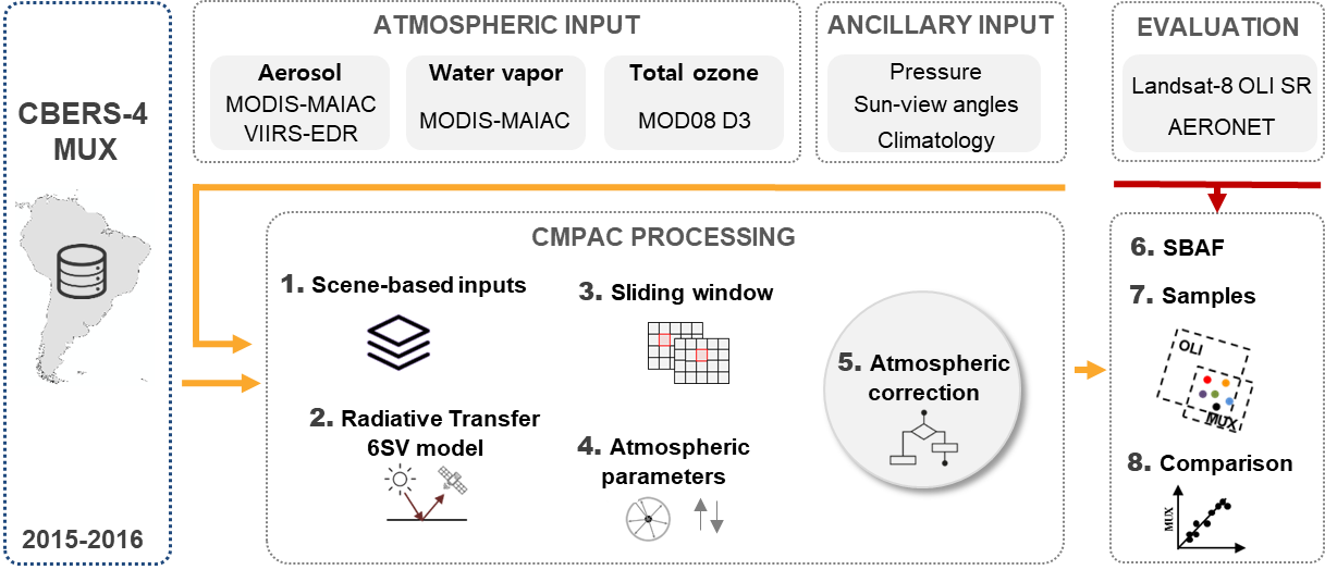
Figure 1. Flowchart for MUX surface reflectance retrievals and its evaluation
About the product
This MUX surface reflectance product contains four spectral bands and new metadata in the zip file. This metadata follows the same structure of Landsat products. In general, CBERS-4 MUX level-4 data provides 8-bit quantization and co-registration at sub-pixel accuracy, and these images were acquired in the http://www.dgi.inpe.br/catalogo/ through of dgipy. The CMPAC is applied in all available images, creating the MUX level-5 product. Note that several images of MUX sensor are available at Level-2, and these images were not processed. Since this is a personal project, you should expect the updates in the website every month. Finally, the scale factor of Level-5 product is 10.000. In other words, the user needs to divide each spectral band by 10.000 to get the surface reflectance between 0 and 1.
Motivation
As I stated in the paper, “The utility of CBERS data comes from its use, and this new product enables the quantitative remote sensing for land monitoring and environmental assessment at 20m spatial resolution”. My personal motivation is to increase the application of CBERS images, and I hope you find it useful. Disclaim: This is not an official product of INPE, and users need to apply the product in their own responsibility.
I would like to thank the LabISA group, especially Claudio Barbosa (PI), Evlyn Novo (PI) and Felipe Menino (Collaborator), for the support in this project.
Data Search
Data acquisition can be made through the data collection tool
Contact: This product is a beta version, and I am glad to receive any feedback (suggestions, problems, etc). Feel free to contact me (Vitor S. Martins, vitorsm@msu.edu).
Martins, V. S., Soares, J. V., Novo, E. M., Barbosa, C. C., Pinto, C. T., Arcanjo, J. S., & Kaleita, A. (2018). Continental-scale surface reflectance product from CBERS-4 MUX data: Assessment of atmospheric correction method using coincident Landsat observations. Remote Sensing of Environment, 218, 55-68. See here